Site Index
Back to Product Page
Click for Price list and order information

KENTUCKY HYDROGRAFX, LLC

SIDESCAN Series
Jonathan Creek
Kentucky Lake (Kentucky)

This series of sidescan imagery covers nearly 2,000 acres of the Jonathan Creek Embayment.
An unbelievable amount of structural features are readily apparent. Use these
images to program your GPS and go right to an ideal spot!

This particular bay resulted in relatively clean sidescan imagery.
Schools of baitfish can cause some areas of clutter, but that was not the case here.

The set includes 12 Extreme resolution sidescan images, 5 Section Index topo
maps, and 1 Master Index map shown below.

See more sidescan images of Jonathan here


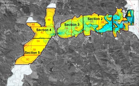
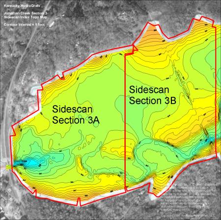
Here is the Master Index map* for the new series. There are 5 major sections divided into a total of 12 extreme resolution sidescan maps.

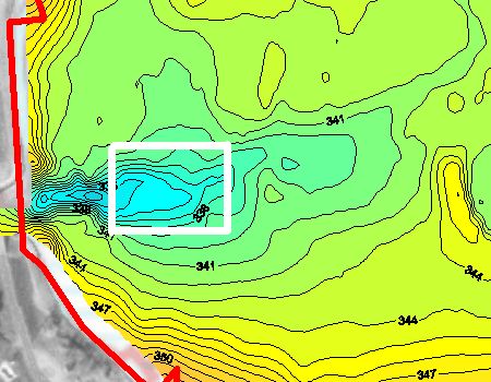
This area includes the original topo coverage of the Jonathan set, plus an addition 1000 acres.

The total area of the area in color represents nearly 2000 acres


* Image resolution reduced to minimize download time.

All Sidescan imagery is georeferenced,
just like conventional HydroGrafx maps.

There are individual index maps for each Section. They are very useful for staying oriented in the extreme zoom levels of the Sidescan images, not to mention the topography.


This a zoomed out view of Sidescan section 3A. The sidescan information is not useable at this range, but this may help orient you to the full resolution example below.


This is a near full resolution sample of Section 3A. It is a deep hole just east of the Hwy 68 bridget. It is in the darker blue

Notice lots of structure on the north side of the hump and very little on the south face.

Click HERE for a larger clip

Keep in mind, this is just a small portion of Section 3A.

The contour interval on all sidescan imagery is 0.5 or 1 foot.


Here is a full resolution sample of the index map showing Section 3A. The area outlined in white is the same area of coverage as the Sidescan image above.

The contour interval on the Section Index maps is 1 foot.

Image quality here is a bit degraded due to compression. This is not the case on the CD.

See more sidescan images of Jonathan here

The Shareware version of OziExplorer mapping software is provided on the disk. The unregistered version will work great with Kentucky HydroGrafx imagery. The registration fee would NOT BE REQUIRED for using the key features of Ozi.

That means you can create waypoints, tracks, or routes that can be uploaded to most GPS units.


Other items included on the CD
(not shown here) include:

A very functional shareware version of OziExplorer GPS Mapping software is provided on disk to get you started with precision fishing. The HydroGrafx images work flawlessly with this version.


Click Here to Purchase

Home Page

If you have any questions about this product, you can email us here pdghahs@kentuckyhydrografx.com

Copyright 2005 Kentucky HydroGrafx, LLC, A Kentucky Limited Liability Company.