Additional Clips of the Kentucky Lake Northeast SS Series
For orientation to scale, each image is 200 feet wide and 150 feet in height.
Each image represents 0.75 acre.
Below are some of the more interesting details that sidescan can reveal.
While a really good sidescan image appears to be a photograph, everything you see below is the result of sonar refections.
This is a clip from Vickers Bay. This is likely a VERY large old stump with much of the dirt eroded away. You can see the actual roots. Most stumps don't show with this much detail since they are not this large. This is outside the mouth of Vickers with the stump at an elevation of approximately 332 (27 feet deep at summer pool).
There are several other stumps/objects around as well.
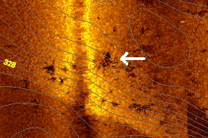
This is a another clip from Vickers bay. The arrows indicate a submerged road bed. The elevation of the roadbed is approximately 330, so it is rather deep.
Notice the linear object just left of the roadbed. Probably an remnant artifact of the old road surface. It is possible it is a tree, but it seems too straight.
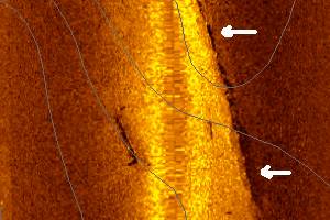
Here is a tree in Vickers Bay. What is quite interesting would be the shadow. It is significantly detached from the sonar return of the tree. The "detached" appearance is caused by the tree being off the bottom. It could have been floating, or maybe a thin root was holding it up.
It is very common with sidescan images for the shadow to be more obvious than the object itself.
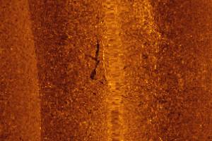
You may initially think these are stumps or other objects randomly scattered along the bottom.
If you look closely at those more toward the left side of the image, you will again notice the shadows "detached" from the object.
This is very likely large fish suspended barely off the bottom. There are a few instances of this in the imagery, but usually not this obvious.
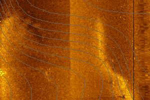
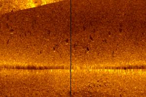
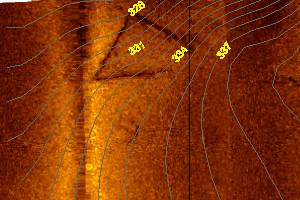
Here is a clip from Higgins Bay. There is a strong indication of a distinct point on the right side of this image. Notice the contour lines don't outline this as they should.
This is a case where the amount of depth data was insufficient to capture the true detail of what is below the surface. Sidescan reveals it quite well.
The contour interval is 1 foot in all sidescan imagery.
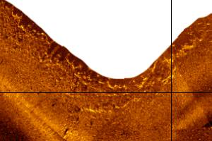
Here is another clip from Higgins Bay. This is a shoreline scan of some large boulders or bedrock.
At Winter pool, these rocks are visible just above the surface, so there is no doubt what the image indicates.
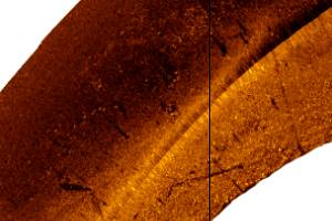
This is a shoreline scan in Sugar Bay. The actual shoreline is at the bottom of the image. The water depth drops dramatically from the shoreline.
You can see 3 trees. 2 are crossed and one less obvious near the right side.
More importantly, notice all the objects in the darker portion. It is important in sidescan interpretation not to ignore what appear to be less obvious items.
This is likely a pallette with stakes attached that has been placed by a fisherman. It has a very subtle shadow extending to the right about the width of the bright return.
While shadows provide critical clues to object height and detail, areas of very soft bottom or silt make shadow development impossible.
The bottom can be so soft that it absorbs all of the sonar signal. In those instances, the shadow cannot be detected. If this pallette had been another 50 feet to the right, it would look much less obvious.
Here is a manmade object approximately 1000 feet outside the mouth of Rhodes bay. The contour lines indicate it is on a slope.
The straight lengths were measured at ~50 feet each. It doesn't have much height since the corresponding shadow is extremely thin parallel to the straight objects.
I don't know what this is. Do You?