Site Index
Back to Product Page
Click for Price list and order information

KENTUCKY HYDROGRAFX, LLC

SIDESCAN Series
Kentucky Lake East Side South
Kentucky Lake (Kentucky & Tennessee)

This series of sidescan imagery covers 2000 acres near the central portion of Kentucky Lake.
Data included resides in both Kentucky and Tennessee (mostly Tennessee).
Use these images to program your GPS and go right to an ideal spot!

The set includes 35 Extreme resolution sidescan images, 10 Section Index topo
maps, and 1 Master Index map shown below.

For several more examples of the sidescan data, see the supplemental images here!

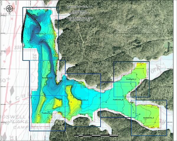
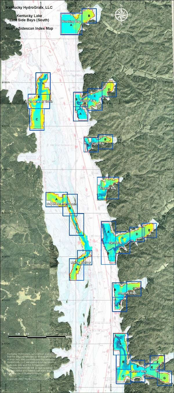
Here is the Master Index map* for the new series. There are 10 major sections divided into a total of 35 extreme resolution sidescan maps.

This area includes the original topo coverage of the Kentucky Lake East Side Bays South, but expanded into the flats in the backs of the bays.

The total acreage of the area in color represents 2000 acres.

The 3 secondary channel sections in the western side of the image are in Kentucky water. The 7 bay datasets on the east side are in Tennessee waters.

* Image resolution reduced to minimize download time.

All Sidescan imagery is georeferenced,
just like conventional HydroGrafx maps.

There are individual index maps for each Section. They are very useful for staying oriented in the extreme zoom levels of the Sidescan images, not to mention the topography.


This a zoomed out view of Sidescan section PantherSS_D. The sidescan information is not useable at this range, but this may help orient you to the full resolution example below.


This is a near full resolution sample of Panther Bay Section D.

This is a location at the point of a major ledge feature. Note the objects near and beyond the base of the slope (close contour lines). A few less obvious objects in the deep flat on the right side of the image.

Keep in mind, this is just a small portion of Panther D.

The dimensions of the image are approximately 380 x 350 feet or 3 acres.

The same area to the left is depicted on the index map below.

The contour interval on all sidescan imagery is 1 foot!


Here is a full resolution sample of the index map showing Panther D. The area outlined in white is the same area of coverage as the Sidescan image above.

The contour interval on the Section Index maps is 2 feet.

All images on this page are degraded due to compression artifacts. Provided data is not degraded.


More sample images of Kentucky Lake East Side Bays Sidescan

The Shareware version of OziExplorer mapping software is provided on the disk. The unregistered version will work great with Kentucky HydroGrafx imagery. The registration fee would NOT BE REQUIRED for using the key features of Ozi.

That means you can create waypoints, tracks, or routes that can be uploaded to most GPS units.


Other items included on the CD
(not shown here) include:

A very functional shareware version of OziExplorer GPS Mapping software is provided on disk to get you started with precision fishing. (The HydroGrafx images work flawlessly with this version.)


Click Here to Purchase

Home Page

If you have any questions about this product, you can email us here pdghahs@kentuckyhydrografx.com

Copyright 2007 Kentucky HydroGrafx, LLC, A Kentucky Limited Liability Company.