All
existing maps for Kentucky and Barkley lakes are based on the topography
when the lakes were impounded many years ago. Although many of the historic
features are still useful today, much has changed since these maps were
created.
More importantly,
many pre-existing terrain details have never been available on map products.
UNTIL NOW!
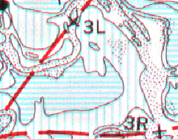
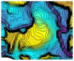
The images above show a section of Blood River as depicted
on the old government chart (103) (left), and the same area that has been
re-mapped (right). The new maps have contour intervals of 0.5 to 2.0 feet,
depending on the amount of elevation change. The example above has a 0.5
foot contour interval.
The maps created by the Tennessee Valley Authority and
the U.S. Army Corps of Engineers are still some of the best paper maps
available for Kentucky and Barkley lakes. More recently produced commercial
maps have significantly reduced resolution and overall topographic detail.
The newest commercial maps do have good detail on non-water related items
such as boat ramps, roads, lodging, etc.
What fisherman need are high quality, high resolution,
high accuracy maps that depict what the lake bottom looks like NOW.
If you want to get on an email list to be notified
when new stuff is completed, just email us at pdghahs@kentuckyhydrografx.com
with a short message to add you to the list.
Here are a few things to think about:
What if your computer could be used to view the NEW maps
and program your GPS for points you click on that map !
What if three dimensional (3D) images were available for
your favorite areas of the lake !
With the advent of highly affordable and
accurate GPS technology, fishermen
can easily find their way back to within 30 feet or less of individual
structure such as stumps, brush piles, points, and creek bends saved in
a previous fishing trip.
Fisherman armed with a GPS and high resolution maps can
find their way to brand new "honey holes" without wasting valuable
time wandering around with eyes glued to depth finder. How many have had
a good map, located many spots they would like to fish and were unable
to find that spot when on the lake??
You know, those places that didn't have any good landmarks
or buoys to "sight" from. You know, those places you zig-zagged,
circled, and were nearly overcome by motion sickness (Oh! that was probably
your buddy) only to finally give up and go back to your "old faithful"
spots before you went home.
|