Using GPS to mark spots while on the lake then returning to them later.
This is how most folks that own GPS devices are using them. It is a very practical use of the device and probably the driving force behind sales of satellite navigation products to fisherman.
I want to expand on this to help you get the most out of your GPS. First, I want to review some of the basics that may help you understand everything else.
If you want to skip the basics, go to I'm close, now how do I get on top of the spot??Waypoints
Most handheld (and console mounted) gps units have the capability of storing waypoints. Waypoints are points in the world that you or somebody else has created with a gps device. Usually a custom symbol that you choose can be assigned to a waypoint. Other information commonly recorded includes the time and date which can be useful for some applications.
The key thing about waypoints is that you can Navigate to them. That means there is a way to select a waypoint by some type of "Go To" function, and the gps will tell you how far it is from your current position and which direction to go. Other common and useful information available when you are "navigating" is ETE (estimated time enroute) and/or ETA (estimated time of arrival).
Routes
Routes are used with navigation and are simply a list of waypoints you have created for the device to "navigate" to.
Most gps units allow for 20 - 50 "legs" in a route. A "leg" is the line between 2 waypoints. For example: If you have a spot you want to fish in the main river channel of a typical lowland reservoir, you usually can't just leave the boat ramp and run in a straight line to that spot. You may have obstacles such as islands or very shallow spots that have to be avoided.
In this example, let's say that the lake you are fishing is very shallow at winter pool and it is critical that you stay in the meandering creek channel until it enters the main river. You will want to create some waypoints while on the water at places the creek channel turns so you can safely get out of the bay at winter pool.
Once you have created waypoints where it is important that you turn, you are ready to define (and name) a ROUTE. The gps should have a menu item for routes and an ability to select which waypoints you want in that route. You want to select the waypoints in the order you would pass them as you leave the dock and head to the river channel. Once you have chosen the last waypoint, your route is now created.
When you select "Go To" a particular route, the gps will tell you the distance and direction you need to travel to reach the first waypoint. Once you have arrived at the first waypoint, the gps will switch to the next waypoint in the route and give you distance and direction to that one. I think you probably get the picture.
The only other thing I want to mention about routes is that you can run them forward or reverse. In the example above, it was run forward. If you are ready to go back to the ramp via your route, you would select the route and chose the option to run in reverse.
Tracks
Most gps devices will save "tracks" showing where you have been. It can be set to save a track point based on time or distance travelled. The end result is a long (usually not straight) line showing your actual path of travel, whether it is by boat, car, foot, or even bicycle. Many devices even allow you to save more than one track.
Tracks are not like waypoints since you can't "navigate" to them. They are only visible on the map display of the gps.
An example of how the track lines can be useful might be drift fishing for crappie. If you were drift fishing an area and after every pass you made, you moved over 100 yards to cover "new water". After several passes, maybe you realized that you were catching less fish than on the initial passes. If your gps was recording a track line, you could easily look at the map display on the gps and see where you initial passes were and start drifting there again. You might just start between the track lines and fish more "new water" between the existing lines.
There are some cool things you can do with "pre-programmed" track lines when used with mapping software. I will expand on that in the "Using GPS mapping software to pre-......" section.
I'm close, now how to I get on top of the spot??
Now that I have reviewed the basic functions of a GPS, I want to explain possible ways to get to a particular spot and position the boat in an optimum location to fish that spot. I will explain this as if you were going to vertical fish a spot and needed to get directly over some type of structure or terrain feature.
You will likely want to use the navigation cababilities of the unit to get you there, whether that be with a route or simply "goto" a waypoint. Once you are navigating to a waypoint, you will usually be shown the distance and bearing to the point along with other information that may be useful to you. That method is ideal for getting you close, but it is a bit trickier getting within a few yards of your destination.
The best way I have found for getting on top of the spot is by using the map display of the gps. The map display is a graphical representation of your location in relation to your destination. This display usually will show a symbol representing the waypoint, a symbol showing your current location and possibly a line (course) that was created when you started "navigating."
When using the map display, you won't necessarily be looking at numbers anymore. That's fine, since our brains comprehend objects on a map and their relationship to each other more readily than just numbers. You will need to have an idea what the scale of the display means and I will discuss that later.
Once you have switched to the "map display," it is important that you know the orientation of North on the display and how to change it if necessary. You usually have 3 options: Track up, North up, or Course up. I personally use Track up or North up and never use Course up.
See scenario below that may help you understand what the gps is telling you based on different display options. The sample shows an Eagle Expedition II handheld gps display. I like to use all 3 display options and I commonly use the NORTH UP option when following a ledge or approaching a waypoint with precision. I will tell you why below.
 |
|
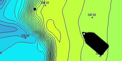
The topo map is for reference and may give you some idea what your depthfinder might show you as you approach the point. Lets assume that you don't have a map with you for this situation. Also you are fishing out of the front of your boat and using your trolling motor to move around. Your gps is mounted in the front of your boat for this example as indicated by the white dot. Another given: You remember from your previous fishing trip that the brushpile was near the top of a ledge as indicated on the map. You saved the waypoint as PNT1. |
 |
 |
 |
|
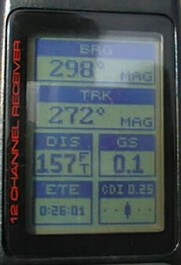
You had used the "goto" function and navigated near the waypoint (PNT1) with the display above. As you can see, you are about 160 feet from the point and it is 298 degrees from your position (roughly northwest). You now want to get right on top of the brushpile.
|
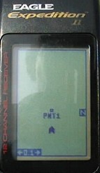
Lets assume you just turned to about 298 degrees, in which case you would be headed directly for the point. If you switched to the map/plotter display, this is what it would show you. In this example, the display is set for TRACK UP. Notice the N(orth) symbol is to your right and up a little. PNT1 is shown directly in front of you. The advantage here is that your target is displayed in a way that is easy to comprehend |
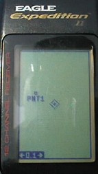
Here is exactly the same situation but with the map/plotter display set for NORTH UP. Your position is the center of the screen and PNT1 is roughly northwest of you. You are still moving toward the point. Also notice the scale indicator. It is showing 0.1 which means that the display width is 0.1 mile wide (or 528 feet) This gives you a rough idea of how far you are from the point. The disadvantage is that you have to constantly think "which way is north?" |
Track up is the easiest for most to comprehend. Track up displays your position as if it were showing what is directly ahead of you. In other words, the top of the display is oriented to the direction you are going.
North up is exactly what it means. No matter which direction you are going, North is always the top of the display. So if you are actually going west (270 degrees), the map dislay will show your position moving from right to left.